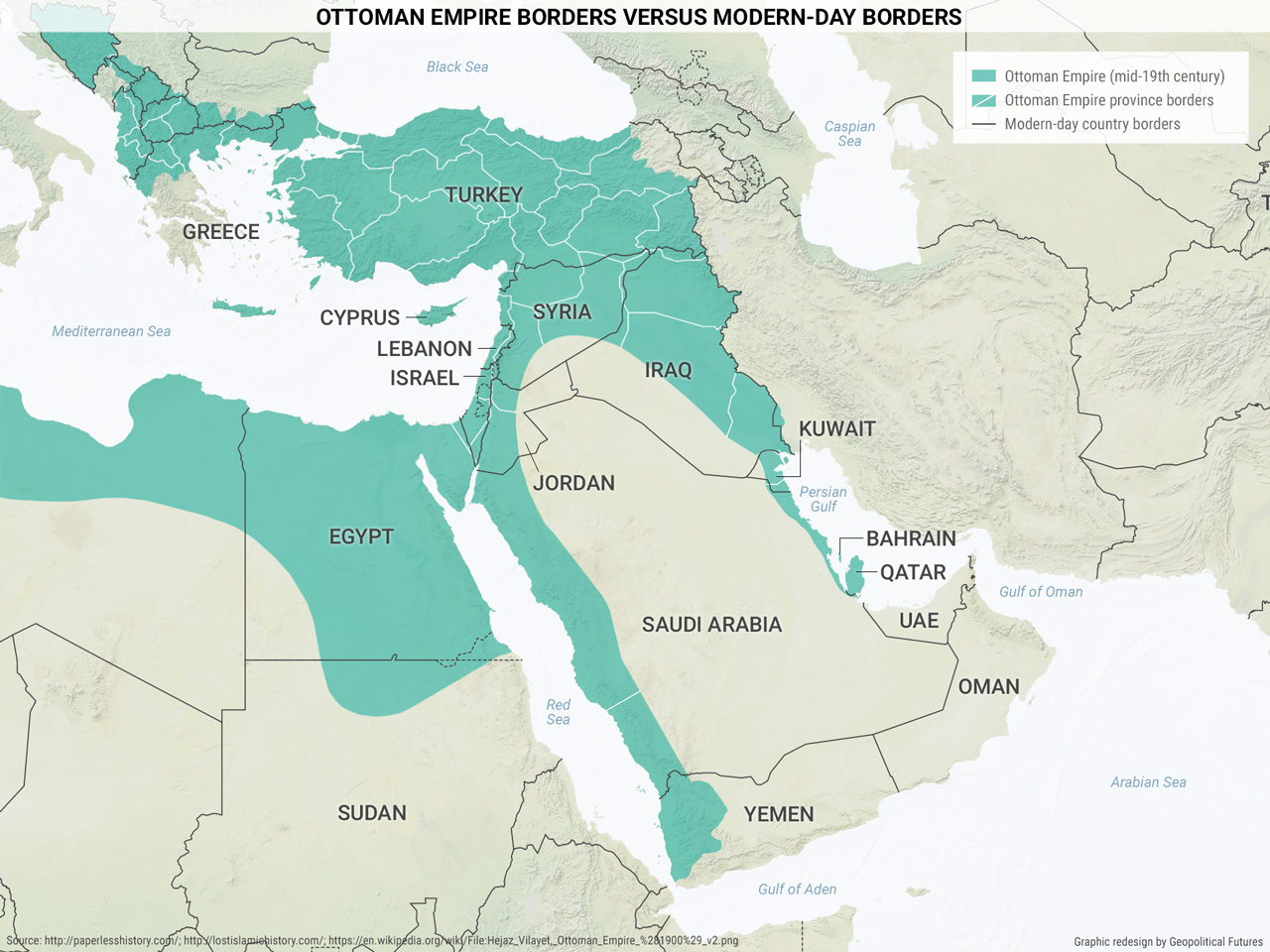
The fine white lines show the boundaries of Ottoman provinces. You will notice that Ottoman provinces, even in modern-day Turkey, which was the core of the empire, were relatively small. There were several explanations for the size of provinces. One was efficiency. Governors and staff managing a small expanse of territory were inherently more efficient than those managing a larger one. Another explanation was political. Ottoman sultans who had also held the title of caliph since the early 16th century did not want to be challenged by governors managing large areas, where they could grow rich and powerful. However, that did happen on occasion, including in Egypt when Muhammad Ali Pasha (an Albanian) was appointed governor in the early 19th century. Smaller provincial governors were weak, poor and could be played off against each other.
But there was another reason for the size of the provinces. Any empire wants to keep peace within its borders. After centuries of rule, the Ottomans understood that the empire was filled with small, hostile clans, tribes, religions and so on. Fusing them together in a single large province promised conflict. Keeping them apart in clever ways, in smaller provinces, limited the opportunities for conflict. The Ottomans also understood that populations shifted, relationships between groups varied and, as things changed, so should the provinces. The Ottomans were constantly tinkering with provincial boundaries. To the extent possible, and with less than perfect success, the Ottomans used these boundaries to keep the peace. The Ottomans understood their domain and created borders that limited conflict.
After World War I, the Ottomans collapsed and the British and French moved in to govern the region south of Turkey. The founder of the Turkish republic, Mustafa Kemal Atatürk, fused the many provinces of modern Turkey into one nation. The British and the French imposed boundaries generally heedless of the Ottoman model, inventing new states with old names from the Turkish border south into the Arabian Peninsula. Syria went to the French, who carved off a small piece for their allies, the Maronite Christians, called Lebanon. The British moved the Hashemites from the western Hejaz region of the Arabian Peninsula to rule Iraq and the eastern bank of the Jordan River, an area called Transjordan, which later became Jordan.
All of these changes made sense from the standpoint of British and French interests and the politics of the region. However, they ignored the boundaries created by the Ottomans. In doing so, they did the opposite of what the Ottomans tried to do. Rather than having small entities containing hopefully compatible groups, they fused hostile groups into large, European-style entities resembling nation-states, as well as small entities that suited their needs.
On a map, these new entities look like nation-states, but they lack the essential character of a European nation-state: commonality. Loaded into Lebanon, for example, were Maronite and Greek Christians, Sunni and Shiite Muslims and Druze, all further divided into hostile clans. Lebanon regularly experienced brutal civil wars that could not be managed by a state that was weaker than its subject groups.
The same was done on a larger scale in Iraq and Syria. Consisting of hostile groups, they could be held together only by foreign powers. When Britain and France lost their empires after World War II, Iraq and Syria were held together by tyrants. And when the tyrants fell or became weak, nothing held them together and these countries plunged into civil war.
The map displays the Ottoman vision of the region, flawed like all such things are but tested over centuries. And it shows the European model, ignoring the Ottoman model, which is now in the process of collapse.
 The World Explained in Maps